Purchase Memberships and Products
Shipping rolled maps or shipping products overseas will incur an additional fee.
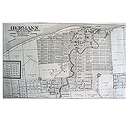
1913 Map of Hermann, Missouri
1913 Map of Hermann, Missouri
$6.00
1913 Map of Hermann, Missouri
This map is a same-size reproduction of the original from Ogle’s Standard Atlas of Gasconade County that shows all city lots identified by number.
Publisher: Gasconade County Historical Society
Dimensions: 28 x 16.5
Quantity: